

 Twitter
 Google+
 Facebook
 LinkedIn
 Digg
Digg del.icio.us
 StumbleUpon
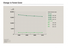
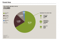
Lao PDR is made up three zones: the northern mountainous region; the central and southern hilly to mountainous region; and the area around the Mekong River and its tributaries (Sophalithath, 2012). It is a highly biodiverse country with 172 mammal species, 212 bird species and 8286 higher plant species (IUCN, 2006). Forests in Lao PDR can be classified into upper mixed deciduous forest, upper dry evergreen forest, and dry dipterocarp forest. Although consistent data on national forest cover are lacking, there are several estimates that indicate overall trends in changes in forest area. According to the Department of Forestry (DoF), using the national definition of forest of >20% tree canopy cover, forest area in 2002 totalled 9.8 million hectares and 41% of the national territory, declining to 9.5 million hectares and 40% of the total land area in 2010 (DOF, 2011). According to the Global Forest Resources Assessment by the United Nations Food and Agriculture Organisation (FAO), using the FAO forest definition of >10% tree canopy cover, forest area in 2002 totalled 16.4 million hectares and 69% of the total land area, and almost 15.8 million hectares and 67% of the total land area in 2010 (FAO, 2010). Although these figures represent relatively modest changes between 2002 and 2010 (a loss of around 35,000 hectares per year), forest cover is reported to have declined drastically in the 10 years prior, between 1992 and 2002, at a rate of 134,000 hectares per year. Plantation forests contribute to these overall totals, and whilst in 2002 were only a minor component of the landscape, plantation area has increased since then, comprising a larger proportion of total forest area.
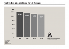
As well as an overall loss in forest cover, forest quality has also deteriorated in the last couple of decades, with dense forest declining from 29% in 1992 to 8.2% in 2002 and open forest increasing from 16% to 24.5%.Forests in Lao PDR hold an estimated 1074 million tonnes of CO2 (FAO, 2010), with deforestation and forest degradation in Lao PDR contributing around 51 million tonnes to annual CO2 emissions (DOF, 2010).
In 2011, the population of Lao PDR was estimated at over 6.2 million (World Bank, 2013). The country consists of 49 ethnic groups and a large number of sub-groups whose livelihoods range from hunting and gathering to various forms of swidden farming in the uplands and wet-rice farming in the plains (King and van de Walle, 2010). The economy has registered an average annual GDP growth of more than 7% in recent years, reaching 8.4% growth in 2010 (World Bank, 2011). The agriculture -forestry sector accounted for 30.4% of the GDP in 2010 and is the largest contributor to national GHG emissions (MPI, 2010).
Forest loss in Lao PDR has numerous drivers including those related to development activities such as agricultural expansion, forestry plantations, mining, hydropower and infrastructure and urban development (Mekong Maps, 2010). These pressures are likely to increase given the country’s target for 2020 of achieving annual economic growth of at least 8% (MPI, 2010). The number of land deals increased fifty fold from 2000 to 2009 (Schonweger et al. 2012) and currently, it is estimated that five million hectares, equal to 21% of the country, are under lease or concession to either domestic or foreign parties (Wellman, 2012).
References
DEPARTMENT OF FORESTRY (DOF). 2010. Forest Carbon Partnership Facility Readiness Preparation Proposal (R-PP). Available here. [Accessed October 2011]
DEPARTMENT OF FORESTRY (DOF). 2011a. Lao PDR Preliminary proposal for FIP. Available here. [Accessed October 2011]
FAO. 2010. Global forest resources assessment 2010. Country Report, Lao PDR. FRA 2010/112. Rome. Available here. [Accessed June 2013]
IUCN. 2006. Can Lao PDR afford not to invest in conserving its biodiversity? 2006. IUCN report, Vientiane, Lao PDR.
KING, E. M., and VAN DE WALLE, D. 2010. Indigenous Peoples. Lao PDR Country Brief No. 2. November 2010. Available here. [Accessed June 2013]
MEKONG MAPS CO LTD. 2010. Analysis of land use and forest changes and related driving forces in the Lao PDR. A contribution to the REDD Readiness Plan. Part I – Main document. Mekong Maps Co Ltd. in cooperation with the Faculty of Forestry and Social Sciences, National University of Lao PDR & the NCCR North-South, University of Bern, Switzerland. Vientiane, Lao PDR.
MINISTRY OF PLANNING AND INVESTMENT (MPI). 2010. Lao PDR 7th National Socio-Economic Development Plan 2011-2015. Available here. [Accessed October 2011]
SCHONWEGER, O., HEINIMANN, A., EPPRECHT, M., LU, J, THALONGSENGCHANH. P.. 2012. Concessions and leases in the Lao PDR: Taking stock of land investments. Centre for Development and Environment (CDE), University of Bern, Bern and Vientiane, Georgpahica Bernensia.
SOPHATHILATH, P. 2012. Assessment of the contribution of forestry to poverty alleviation in Lao People’s Democratic Republic. In: Making forestry work for the poor. Assessment of the contribution of forestry to poverty alleviation in Asia and the Pacific. RAP Publication No.: 2012/06. Food and Agriculture Organization of the United Nations Regional Office for Asia and the Pacific. Bangkok, 2012.
WELLMAN, D. 2012. Discussion paper on the Legal Framework of State Land Leases and Concessions in the Lao PDR. Intergrated Rural Develoopment in Poverty Regions of Laos (IRDP) under the Northern Upland Development Project. Available here. [Accessed June 2013]
WORLD BANK. 2013. Lao PDR Overview. Available here. [Accessed June 2013]