

 Twitter
 Google+
 Facebook
 LinkedIn
 Digg
Digg del.icio.us
 StumbleUpon
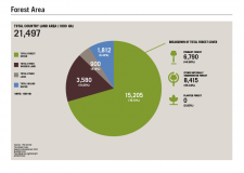
Guyana has one of the highest proportions of forest cover of any country in the world. The FAO estimates that the total land area of just over 21 million hectares is comprised of 71% of forest and 17% of ‘other wooded land’ (FAO 2010). A recent study places the area of forest in Guyana at 18.4 million hectares, equivalent to 87% (GFC 2012). The major types of forest are rainforest, seasonal forest, dry evergreen forest, marsh forest (including mangrove and swamp forest) and mountain forest (ITTO 2005).
Guyana is a constituent of the wider Guiana Shield Rainforest that also covers Suriname, French Guiana and part of Venezuela and Brazil. This rainforest is one of the largest expanses of untouched tropical rainforest in the world. It contains a high level of biodiversity with estimates in the range of more than 1,200 vertebrate species and more than 6,000 plant species present in Guyana (ITTO 2005). Many of these are endemic and/or vulnerable with 68 of Guyana’s species on the International Union for Conservation of Nature’s (IUCN) Red List (IUCN 2011).
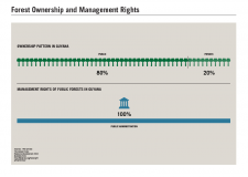
Historically Guyana has experienced very low rates of deforestation with the FAO reporting zero rates of deforestation back to 1990. A recent study, the first of its kind in Guyana, identified deforestation rates of 0.06% for 2009-2010, rising from 0.02% per annum between 2005 and 2009 (GFC & Poyry 2011). An update to the study estimated the rate between 2010 and 2011 at 0.054% (GFC 2012). The majority of deforestation between 2009 and 2011 has been attributed to increased mining activity accounting for 91% of the deforestation in 2009-2010 and 93% in 2010-2011. This mining activity is a crucial part of Guyana’s economy, however, representing 21% of GDP in 2012 (Guyana Bureau of Statistics 2012), while gold and bauxite made up over 60% of all exports by value in 2012 (Guyana Bureau of Statistics 2012). 84% of the forested area in Guyana is under state ownership and management through the State Forest Estate (67%) and State Lands (17%) (GFC 2012). The majority of the remaining forested area is held through communal rights as Amerindian community ownership (14%).
References
FAO. 2010. Global Forest Resource Assessment.
GUYANA BUREAU OF STATISTICS. 2012. Imports and Exports 2012.
GUYANA BUREAU OF STATISTICS 2013, Guyana Rebased Gross Domestic Product Series
GUYANA AND FORESTRY COMMISSION AND POYRY FORESTRY INDUSTRY (GFC and Poyry). 2011. Guyana REDD+ Monitoring, Reporting and Verification System (MRVS) Interim Measures Report.
GUYANA FORESTRY COMMISSION (GFC) 2012, Guyana Forestry Commission Guyana REDD + Monitoring Reporting & Verification System ( MRVS ) Interim Measures Report 01 October 2010 – 31 December 2011 Version 3
INTERNATIONAL TROPICAL TIMBER ORGANIZATION. 2005. Guyana Country Profile.
IUCN. 2011. IUCN Red List of Threatened Species. Version 2011.1. Available here. [Accessed 16 June 2011]